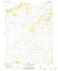
1961 Map of Ohio
USGS Topo · Published 1979About this map
Strip mines scar the landscape of northern St. Clair County in the early 1960s, reflecting a transition in land use across the Fairview and Chalk Level regions. The map centers on the small settlement of Ohio, positioned near the confluence of local drainages and just south of the Henry County and St. Clair County line. This survey captures a rural environment where agriculture and extractive industry coexist, documented through a dense network of family and community landmarks.
Find a feature on this map
22 named features on this map. Tap any name to fly to it.
Don’t see what you’re looking for? This feature index may not catch every label — zoom into the map to look around manually.
Map Details
Editions of this 1961 Ohio Map
2 editions found
Other maps of this area

1887 · Clinton
USGS Topo · 1:125,000

1894 · Clinton
USGS Topo · 1:125,000

1938 · Monegaw Springs
USGS Topo · 1:24,000

1938 · Taberville
USGS Topo · 1:24,000

1939 · Osceola
USGS Topo · 1:24,000

1940 · Taberville
USGS Topo · 1:24,000

1940 · Osceola
USGS Topo · 1:24,000
1940 · Monegaw Springs
USGS Topo · 1:24,000

1941 · Lowry City
USGS Topo · 1:24,000

1945 · Lowry City
USGS Topo · 1:24,000