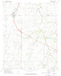
1972 Map of Okarche
USGS Topo · Published 1974About this map
The Old Indian Treaty Boundary slices diagonally across this prairie landscape, marking a significant historical line in central Oklahoma. The town of Okarche sits at the intersection of the Kingfisher Co and Canadian Co line, serving as a focal point for the surrounding agricultural community. The Chicago Rock Island and Pacific railroad runs north-south through the center of town, parallel to the main highway, anchoring the local economy.
Find a feature on this map
20 named features on this map. Tap any name to fly to it.
Don’t see what you’re looking for? This feature index may not catch every label — zoom into the map to look around manually.
Map Details
Editions of this 1972 Okarche Map
This is the sole edition of this map. No revisions or reprints were ever made.
Other maps of this area

1892 · Kingfisher
USGS Topo · 1:125,000

1893 · Fort Reno
USGS Topo · 1:62,500

1893 · Loyal
USGS Topo · 1:62,500

1895 · Kingfisher
USGS Topo · 1:125,000

1941 · Fort Reno
USGS Topo · 1:62,500

1942 · Fort Reno
USGS Topo · 1:62,500

1949 · Fort Reno
USGS Topo · 1:62,500

1954 · Oklahoma City
USGS Topo · 1:250,000

1955 · Clinton
USGS Topo · 1:250,000

1957 · Clinton
USGS Topo · 1:250,000