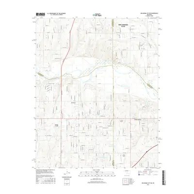
2016 Map of Oklahoma City SW
USGS Topo · Published 2016About this map
The Canadian River meanders across this landscape south of Oklahoma City, defining the borders where Canadian, Grady, Cleveland, and McClain Counties meet. This 2016 survey shows the rapid residential expansion surrounding the established communities of Tuttle, Newcastle, and Bridge Creek. While much of the land maintains its rural character with section-line roads like N Co Line Rd and S Sara Rd, the map reveals specialized aviation landmarks including Low Pass Airport and the Cole Landing Area. Local topography is punctuated by Bartons Butte and Cedar Hill, while the Timberlake Reservoir and numerous creeks like Coal Cr and Worley Cr drain the rolling terrain. For those researching local heritage, the Clopton Cem remains a primary genealogical landmark in the southeastern quadrant.
Find a feature on this map
131 named features on this map. Tap any name to fly to it.
Don’t see what you’re looking for? This feature index may not catch every label — zoom into the map to look around manually.
Map Details
Editions of this 2016 Oklahoma City SW Map
This is the sole edition of this map. No revisions or reprints were ever made.
Other maps of this area

1893 · Oklahoma City
USGS Topo · 1:62,500

1893 · Minco
USGS Topo · 1:62,500

1904 · Chickasha
USGS Topo · 1:125,000

1954 · Oklahoma City
USGS Topo · 1:250,000

1956 · Oklahoma City
USGS Topo · 1:24,000

1956 · Oklahoma City
USGS Topo · 1:62,500

1956 · Oklahoma City SE
USGS Topo · 1:24,000

1957 · Oklahoma City
USGS Topo · 1:250,000

1963 · Oklahoma City
USGS Topo · 1:250,000
1965 · Newcastle
USGS Topo · 1:24,000