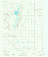
1964 Map of Oklahoma Flat
USGS Topo · Published 1981About this map
Yellow House Ranch and the open plains of the South Plains dominate this landscape, where the boundary of Lamb and Hockley counties crosses a unique chain of alkaline depressions. The terrain is defined by the significant catchments of Illusion Lake and Yellow Lake, which sit within a broader drainage system including Bull Draw and Yellow House Draw. The map captures a transition in land use, showing the traditional ranching infrastructure alongside the development of the Yellow House Oil Field. Scattered throughout the area are specialized water features essential for High Plains life, such as Rattlesnake Tank, South Pasture Windmill, and East Windmill. Evidence of local industry is visible in several Gravel Pits and the small settlement of Oklahoma Flat at the eastern edge.
Find a feature on this map
21 named features on this map. Tap any name to fly to it.
Don’t see what you’re looking for? This feature index may not catch every label — zoom into the map to look around manually.
Map Details
Editions of this 1964 Oklahoma Flat Map
2 editions found
Other maps of this area

1954 · Brownfield
USGS Topo · 1:250,000

1958 · Brownfield
USGS Topo · 1:250,000

1962 · Brownfield
USGS Topo · 1:250,000

1964 · Oklahoma Flat
USGS Topo · 1:24,000

1964 · Littlefield
USGS Topo · 1:24,000
1964 · Bull Lake
USGS Topo · 1:24,000

1964 · Pep
USGS Topo · 1:24,000

1964 · Lums Chapel
USGS Topo · 1:24,000
1964 · Beck
USGS Topo · 1:24,000

1964 · Whitharral
USGS Topo · 1:24,000