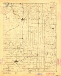
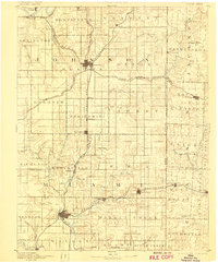
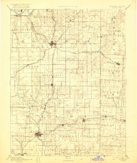
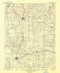
1893 Map of Olathe
USGS Topo · Published 1900About this map
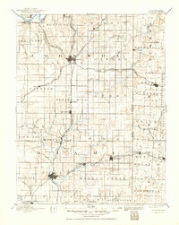
Olathe and Paola anchor this late-nineteenth-century survey of the Kansas-Missouri borderlands, showing a landscape defined by an expanding network of steam transportation. The convergence of the Atchison Topeka & Santa Fe Railroad and the Kansas City Fort Scott and Gulf Railroad at Olathe illustrates the town's role as a regional transit hub. Smaller trackside settlements like Bonita, Ocheltree, and Hillsdale appear at regular intervals along these steel corridors, while older road-oriented locations like New Santa Fe represent the earlier era of overland travel. To the east, the Kansas Missouri Boundary Line bisects the drainage of the Blue River, separating the townships of Oxford and Washington. The map documents numerous creeks and their branches, including Big Bull Creek and Wea Creek, which dictated the early placement of farms and small communities like Somerset and Louisburg before the full maturation of the regional rail grid.
Find a feature on this map
93 named features on this map. Tap any name to fly to it.
Don’t see what you’re looking for? This feature index may not catch every label — zoom into the map to look around manually.
Map Details
Editions of this 1893 Olathe Map
6 editions found

Other maps of this area

1885 · Garnett
USGS Topo · 1:125,000

1885 · Lawrence
USGS Topo · 1:125,000

1886 · Oskaloosa
USGS Topo · 1:125,000

1887 · Harrisonville
USGS Topo · 1:125,000

1887 · Olathe
USGS Topo · 1:125,000

1887 · Butler
USGS Topo · 1:125,000

1887 · Mound City
USGS Topo · 1:125,000

1888 · Oskaloosa
USGS Topo · 1:125,000

1889 · Lawrence
USGS Topo · 1:125,000

1890 · Kansas City
USGS Topo · 1:125,000