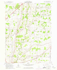
1961 Map of Olive Green
USGS Topo · Published 1974About this map
Big Walnut Creek meanders through the heart of the United States Military District in Delaware and Morrow counties, anchoring a landscape of small agricultural hamlets and crossroads. The map captures a traditional rural network of rural routes and farmsteads just before modern expansion began to alter the region's character. Significant community centers like Olive Green and Pagetown are depicted alongside their essential institutions, including the Pagetown Cem and various country churches such as Blue Ch and Mt Pleasant Ch. A notable local landmark is the Covered Bridge crossing the Walnut, reflecting the area's 19th-century infrastructure surviving into the mid-20th century. The Penn Central railroad cuts through the northeastern and southern sections, providing a vital link for settlements like North Condit and Vails Corners. Smaller waterways like Indigo Creek and Sugar Creek drain the fertile till plains, which are divided into the townships of Kingston, Porter, and Berkshire.
Find a feature on this map
36 named features on this map. Tap any name to fly to it.
Don’t see what you’re looking for? This feature index may not catch every label — zoom into the map to look around manually.
Map Details
Editions of this 1961 Olive Green Map
3 editions found
Other maps of this area

1902 · Westerville
USGS Topo · 1:62,500

1904 · Westerville
USGS Topo · 1:62,500

1908 · Granville
USGS Topo · 1:62,500

1910 · Granville
USGS Topo · 1:62,500

1915 · Marengo
USGS Topo · 1:62,500

1915 · Fredericktown
USGS Topo · 1:62,500

1943 · Marengo
USGS Topo · 1:62,500

1943 · Fredericktown
USGS Topo · 1:62,500

1950 · Marion
USGS Topo · 1:250,000
1955 · Sunbury
USGS Topo · 1:24,000