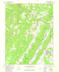
1968 Map of Onego
USGS Topo · Published 1982About this map
Seneca Rocks stands as a prominent geological landmark in this part of Pendleton County, overlooking the junction of Seneca Creek and the North Fork Potomac River. The landscape is dominated by the ridges of Smith Mtn and Timber Ridge, with much of the territory managed as part of the Monongahela National Forest. Small mountain settlements like Onego, Teterton, and Macksville are connected by valley roads, while the higher elevations feature family-named peaks such as Kisamore Knob and Germany Knob. Deep within the valley, Seneca Caverns and the Seneca Campground suggest a long-standing pattern of recreational use. Resource extraction is noted at a Mine and Quarry, while the presence of a Compressor Station and an extensive Pipeline network indicates the integration of this rural highland into regional energy infrastructure.
Find a feature on this map
50 named features on this map. Tap any name to fly to it.
Don’t see what you’re looking for? This feature index may not catch every label — zoom into the map to look around manually.
Map Details
Editions of this 1968 Onego Map
3 editions found
Other maps of this area

1889 · Beverly
USGS Topo · 1:125,000

1892 · Beverly
USGS Topo · 1:125,000

1892 · Franklin
USGS Topo · 1:125,000

1896 · Franklin
USGS Topo · 1:125,000

1920 · Onego
USGS Topo · 1:62,500

1921 · Onego
USGS Topo · 1:48,000

1922 · Onego
USGS Topo · 1:62,500

1922 · Horton
USGS Topo · 1:48,000

1922 · Spruce Knob
USGS Topo · 1:48,000

1922 · Circleville
USGS Topo · 1:62,500