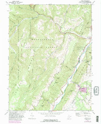
1968 Map of Onego
USGS Topo · Published 1988About this map
Seneca Rocks towers over this pocket of the Appalachian Highlands, where the North Fork South Branch Potomac River carves a deep valley between Little Mountain and the Knobs. Recorded in the late 1960s with revisions through 1981, this map details a landscape defined by the Monongahela National Forest and its recreational landmarks, including Seneca Caverns and the Seneca Campground. Small valley settlements like Onego, Teterton, and Macksville are scattered along the riverbanks, connected by a network of rural roads and mountain gaps such as Tanyard Gap and Hinkle Gap. The presence of Sidwells Ch and numerous mountain-side cemeteries illustrates the deep-rooted local history in these remote ridges. Above the river, the terrain rises sharply to Spruce Knob Mountain, while industrial activity is represented by a single Mine and a natural gas Compressor Station.
Find a feature on this map
50 named features on this map. Tap any name to fly to it.
Don’t see what you’re looking for? This feature index may not catch every label — zoom into the map to look around manually.
Map Details
Editions of this 1968 Onego Map
3 editions found
Other maps of this area

1889 · Beverly
USGS Topo · 1:125,000

1892 · Beverly
USGS Topo · 1:125,000

1892 · Franklin
USGS Topo · 1:125,000

1896 · Franklin
USGS Topo · 1:125,000

1920 · Onego
USGS Topo · 1:62,500

1921 · Onego
USGS Topo · 1:48,000

1922 · Onego
USGS Topo · 1:62,500

1922 · Horton
USGS Topo · 1:48,000

1922 · Spruce Knob
USGS Topo · 1:48,000

1922 · Circleville
USGS Topo · 1:62,500