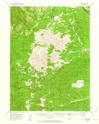
1952 Map of Ono
USGS Topo · Published 1962About this map
Ono and Gas Point serve as the primary hubs in this mid-century survey of the rugged transition between the Sacramento Valley and the Klamath Mountains. The landscape is defined by the complex drainage of Cottonwood Creek and its many tributaries, including Roaring River and the North Fork Cottonwood Creek. Evidence of the region's resource-based economy is visible through the tailings marked near the Cottonwood Road and various gulches like Coal Pit Gulch and Dutch Gulch. The boundary between Shasta and Tehama counties winds through the southern portion of the sheet, crossing high points like Chickabally Mtn. Scattered landmarks such as Pentacola Field, Crow Flat, and several cemeteries provide specific points of interest for those tracing the family names and early rural infrastructure of these northern California foothills before modern development shifted the local footprint.
Find a feature on this map
59 named features on this map. Tap any name to fly to it.
Don’t see what you’re looking for? This feature index may not catch every label — zoom into the map to look around manually.
Map Details
Editions of this 1952 Ono Map
3 editions found

Other maps of this area

1890 · Red Bluff
USGS Topo · 1:250,000

1894 · Red Bluff
USGS Topo · 1:250,000

1901 · Redding
USGS Topo · 1:125,000

1913 · Weaverville
USGS Topo · 1:125,000

1932 · Olinda
USGS Topo · 1:31,680

1935 · Olinda
USGS Topo · 1:31,680

1944 · Redding
USGS Topo · 1:62,500

1944 · French Gulch
USGS Topo · 1:62,500

1946 · Redding
USGS Topo · 1:62,500

1947 · Anderson
USGS Topo · 1:62,500