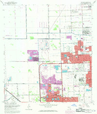
1962 Map of Opa-locka
USGS Topo · Published 1970About this map
The Opa-locka Airport and the sprawling grounds of the South Florida State Hospital dominate the landscape of North Dade in this era of rapid suburban expansion. Purple map revisions from 1969 reveal the explosive growth of residential neighborhoods like Carol City and Palm Springs North, where new subdivisions began to fill the spaces between established water control features like the Snake Creek Canal and the Biscayne Canal. The map records a complex aviation and military history, showing both the Gunnery Range (Abandoned) and the Amelia Earhart Field (Abandoned) alongside active industrial sites and the Seaboard Coast Line railroad. Local community life is anchored by numerous institutions, including the Vista Memorial Gardens (Cemetery), Pace High Sch, and several churches such as Life Tabernacle and St Anthonys Ch.
Find a feature on this map
82 named features on this map. Tap any name to fly to it.
Don’t see what you’re looking for? This feature index may not catch every label — zoom into the map to look around manually.
Map Details
Editions of this 1962 Opa-locka Map
4 editions found

Other maps of this area

1947 · North Miami
USGS Topo · 1:24,000

1949 · Opalocka
USGS Topo · 1:24,000

1949 · Fort Lauderdale South
USGS Topo · 1:24,000

1950 · Hialeah
USGS Topo · 1:24,000

1950 · Miami
USGS Topo · 1:24,000

1950 · North Miami
USGS Topo · 1:24,000

1956 · Miami
USGS Topo · 1:250,000

1956 · West Palm Beach
USGS Topo · 1:250,000

1957 · West Palm Beach
USGS Topo · 1:250,000

1958 · West Palm Beach
USGS Topo · 1:250,000