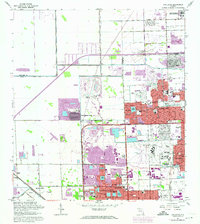
1962 Map of Opa-locka
USGS Topo · Published 1974About this map
Opa-locka Airport and the surrounding urban expansion of northern Miami-Dade County define this era of rapid residential growth. While the core of Opa-locka and Carol City show established street grids, significant purple-tinted revisions from 1969 and 1973 reveal a landscape in transition, where previous open spaces are being filled with housing developments and artificial lakes. These man-made water bodies, such as Lake Steven and Lake Catalina, illustrate the drainage and landfill patterns common to South Florida's mid-century suburbanization. Aviation history is particularly prominent here, featuring both the active airport and the Amelia Earhart Field (Abandoned). The northern boundary is marked by the South Florida State Hospital and Snake Creek, while the western edge remains relatively undeveloped around Pennsuco and Graham Mission. Local institutional history is captured through numerous churches like St Anthony Ch and educational centers such as Biscayne College.
Find a feature on this map
77 named features on this map. Tap any name to fly to it.
Don’t see what you’re looking for? This feature index may not catch every label — zoom into the map to look around manually.
Map Details
Editions of this 1962 Opa-locka Map
4 editions found

Other maps of this area

1947 · North Miami
USGS Topo · 1:24,000

1949 · Opalocka
USGS Topo · 1:24,000

1949 · Fort Lauderdale South
USGS Topo · 1:24,000

1950 · Hialeah
USGS Topo · 1:24,000

1950 · Miami
USGS Topo · 1:24,000

1950 · North Miami
USGS Topo · 1:24,000

1956 · Miami
USGS Topo · 1:250,000

1956 · West Palm Beach
USGS Topo · 1:250,000

1957 · West Palm Beach
USGS Topo · 1:250,000

1958 · West Palm Beach
USGS Topo · 1:250,000