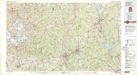
1981 Map of Opelika
USGS Topo · Published 1982About this map
The Tallapoosa River and Chattahoochee River define the industrial and recreational geography of this East Alabama and West Georgia borderland. Significant reservoir development is evident at Lake Martin and West Point Lake, while the Central of Georgia and Western Railway of Alabama lines trace the historical movement of goods through the textile corridor of Lanett, Langdale, and River View.
Find a feature on this map
107 named features on this map. Tap any name to fly to it.
Don’t see what you’re looking for? This feature index may not catch every label — zoom into the map to look around manually.
Map Details
Editions of this 1981 Opelika Map
This is the sole edition of this map. No revisions or reprints were ever made.
Other maps of this area

1890 · Talladega
USGS Topo · 1:125,000

1891 · Ashland
USGS Topo · 1:125,000

1892 · Talladega
USGS Topo · 1:125,000

1899 · Wedowee
USGS Topo · 1:125,000

1901 · Wetumpka
USGS Topo · 1:125,000

1901 · Wetumpka
USGS Topo · 1:62,500

1902 · Wedowee
USGS Topo · 1:125,000

1903 · Wetumpka
USGS Topo · 1:125,000

1906 · Dadeville
USGS Topo · 1:125,000

1907 · Talbotton
USGS Topo · 1:125,000