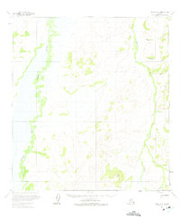
1954 Map of Ophir A-3
USGS Topo · Published 1975About this map
The Dishna River meanders across this interior landscape, marking a terrain of vast floodplains and wetlands in the mid-1950s. To the east, the drainage basin of Tolstoi Creek dominates the topography, fed by several smaller tributaries including Dome Creek, Donovan Creek, and Baker Creek. This era of Alaskan exploration is captured through the lens of early photogrammetric mapping, which identifies the Hunter Trail cutting through the southern portion of the quadrangle. A solitary topographic high point known as Dish stands as a primary landmark amidst the intricate network of waterways and shifting river channels. The map illustrates the region as it existed before significant modern alterations, detailing the natural hydrology that dictated travel and survival in this remote stretch of the Yukon-Koyukuk region.
Find a feature on this map
7 named features on this map. Tap any name to fly to it.
Don’t see what you’re looking for? This feature index may not catch every label — zoom into the map to look around manually.
Map Details
Editions of this 1954 Ophir A-3 Map
2 editions found
Other maps of this area

1951 · Ophir
USGS Topo · 1:250,000

1951 · Iditarod
USGS Topo · 1:250,000

1954 · Ophir A-2
USGS Topo · 1:63,360

1954 · Iditarod D-2
USGS Topo · 1:63,360

1954 · Ophir A-3
USGS Topo · 1:63,360

1954 · Ophir A-4
USGS Topo · 1:63,360

1954 · Ophir B-4
USGS Topo · 1:63,360

1954 · Ophir B-2
USGS Topo · 1:63,360

1954 · Iditarod D-3
USGS Topo · 1:63,360

1954 · Iditarod D-4
USGS Topo · 1:63,360