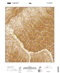
2019 Map of Ophir C-1 NE
USGS Topo · Published 2019About this map
Hunch Mtn dominates the high ground of this interior Alaska wilderness, serving as a primary drainage divide for the surrounding valley systems. This 2019 survey, compiled from data by the U.S. Geological Survey and the Alaska Dept. of Transportation, illustrates a landscape defined by its remote watercourses. To the north and west, the headwaters of Hunch Cr and Colorado Cr carve through the terrain, while the southern slopes feed into Graham Cr. The map preserves the formal Public Land Survey System boundaries, including the intersection of t20s r14e and t21s r14e. This document provides a precise record of the topographical relief and hydraulic patterns in a region where few permanent settlements or roads exist, highlighting the natural geography of the Yukon-Koyukuk Census Area.
Find a feature on this map
10 named features on this map. Tap any name to fly to it.
Don’t see what you’re looking for? This feature index may not catch every label — zoom into the map to look around manually.
Map Details
Editions of this 2019 Ophir C-1 NE Map
This is the sole edition of this map. No revisions or reprints were ever made.
Other maps of this area

1950 · Medfra
USGS Topo · 1:250,000

1951 · Ophir
USGS Topo · 1:250,000

1954 · Medfra C-6
USGS Topo · 1:63,360

1954 · Medfra D-6
USGS Topo · 1:63,360
1954 · Ophir D-1
USGS Topo · 1:63,360

1954 · Ophir C-1
USGS Topo · 1:63,360

1954 · Ophir
USGS Topo · 1:250,000

1959 · Medfra
USGS Topo · 1:250,000
2019 · Medfra C-6 SW
USGS Topo · 1:25,000
2019 · Ophir D-1 SE
USGS Topo · 1:25,000