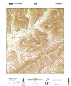
2017 Map of Ophir D-3 NE
USGS Topo · Published 2017About this map
Mud River meanders through the heart of this interior Alaskan landscape, defining the low-lying drainage patterns within the Yukon-Koyukuk region. The terrain is characterized by complex contour elevations that rise away from the river valley, particularly in the southeastern quadrant where Galatea Cr cuts through the uplands. This 2017 survey highlights a vast, roadless wilderness where the natural hydrology and topographical relief are the primary features, illustrating a remote portion of the state defined more by its watershed than by human settlement. The map serves as a primary record of the Public Land Survey System for the area, delineating the boundaries of T17S R8E and T18S R9E among others, providing a clear view of the township and range divisions that overlay this undeveloped expanse.
Find a feature on this map
8 named features on this map. Tap any name to fly to it.
Don’t see what you’re looking for? This feature index may not catch every label — zoom into the map to look around manually.
Map Details
Editions of this 2017 Ophir D-3 NE Map
This is the sole edition of this map. No revisions or reprints were ever made.
Other maps of this area

1945 · Nulato
USGS Topo · 1:250,000

1951 · Ophir
USGS Topo · 1:250,000

1951 · Nulato
USGS Topo · 1:250,000

1952 · Nulato A-2
USGS Topo · 1:63,360

1952 · Nulato A-3
USGS Topo · 1:63,360

1952 · Nulato
USGS Topo · 1:250,000
1954 · Ophir D-3
USGS Topo · 1:63,360
1954 · Ophir D-2
USGS Topo · 1:63,360

1954 · Ophir
USGS Topo · 1:250,000

1964 · Nulato
USGS Topo · 1:250,000