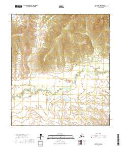
2017 Map of Ophir D-3 NW
USGS Topo · Published 2017About this map
Mud River meanders across the southern half of this interior Alaskan landscape, creating a complex network of wetlands and oxbows within the Yukon-Koyukuk Census Area. The terrain is defined by the significant rise of the Tlatl Hills in the northeastern quadrant, where elevations climb above 1,100 feet from the river basin. This 2017 survey documents a wilderness environment devoid of permanent roads or settlements, highlighting the vast, untouched nature of the Alaskan interior at the start of the 21st century. The map provides a detailed view of the natural drainage patterns and topographical relief in the areas surrounding t18s r8e and neighboring townships.
Find a feature on this map
8 named features on this map. Tap any name to fly to it.
Don’t see what you’re looking for? This feature index may not catch every label — zoom into the map to look around manually.
Map Details
Editions of this 2017 Ophir D-3 NW Map
This is the sole edition of this map. No revisions or reprints were ever made.
Other maps of this area

1945 · Nulato
USGS Topo · 1:250,000

1951 · Ophir
USGS Topo · 1:250,000

1951 · Nulato
USGS Topo · 1:250,000

1952 · Nulato A-4
USGS Topo · 1:63,360

1952 · Nulato A-3
USGS Topo · 1:63,360

1952 · Nulato
USGS Topo · 1:250,000
1953 · Nulato A-4
USGS Topo · 1:63,360
1954 · Ophir D-4
USGS Topo · 1:63,360
1954 · Ophir D-3
USGS Topo · 1:63,360

1954 · Ophir
USGS Topo · 1:250,000