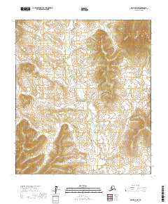
2017 Map of Ophir D-5 NW
USGS Topo · Published 2017About this map
The Innoko National Wildlife Refuge dominates this section of the interior, protecting a vast wetland landscape where the Kaiyuh Mountains rise as a prominent topographic boundary. This 2017 survey details a wilderness defined by its complex drainage systems, specifically the winding courses of Magitchlie Cr and Roketaloi Cr. These waterways meander through a series of townships and ranges, including t18s r2e and t18s r3e, illustrating the remote nature of the Yukon-Koyukuk region. The map provides a clear look at the elevation changes between the low-lying creek basins and the upland terrain of the Kaiyuh range, showing an environment shaped by water and high-latitude topography without the footprint of modern infrastructure or permanent settlements.
Find a feature on this map
10 named features on this map. Tap any name to fly to it.
Don’t see what you’re looking for? This feature index may not catch every label — zoom into the map to look around manually.
Map Details
Editions of this 2017 Ophir D-5 NW Map
This is the sole edition of this map. No revisions or reprints were ever made.
Other maps of this area

1945 · Nulato
USGS Topo · 1:250,000

1951 · Ophir
USGS Topo · 1:250,000

1951 · Nulato
USGS Topo · 1:250,000

1952 · Nulato A-5
USGS Topo · 1:63,360

1952 · Nulato
USGS Topo · 1:250,000

1952 · Nulato A-6
USGS Topo · 1:63,360
1954 · Ophir D-6
USGS Topo · 1:63,360
1954 · Ophir D-5
USGS Topo · 1:63,360

1954 · Ophir
USGS Topo · 1:250,000

1964 · Nulato
USGS Topo · 1:250,000