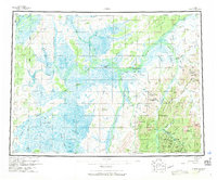
1954 Map of Ophir
USGS Topo · Published 1971About this map
Ophir stands as the primary hub of activity in this 1954 survey of the Alaskan interior, centered on the Innoko River and its gold-bearing tributaries. The map documents a landscape in transition, where several former outposts such as Dementi, Dishkakat, and Rennies Landing are marked as abandoned, indicating the shift in settlement patterns as the early 20th-century mining booms subsided. Despite these departures, industrial traces remain prominent, notably at the Ganes Creek Mine and the Esperanto Placer Mine along the eastern drainages.
Find a feature on this map
53 named features on this map. Tap any name to fly to it.
Don’t see what you’re looking for? This feature index may not catch every label — zoom into the map to look around manually.
Map Details
Editions of this 1954 Ophir Map
3 editions found

Other maps of this area

1945 · Nulato
USGS Topo · 1:250,000

1948 · Norton Bay
USGS Topo · 1:250,000

1949 · McGrath
USGS Topo · 1:250,000

1950 · Medfra
USGS Topo · 1:250,000

1950 · McGrath
USGS Topo · 1:250,000

1951 · Ophir
USGS Topo · 1:250,000

1951 · Nulato
USGS Topo · 1:250,000

1951 · Unalakleet
USGS Topo · 1:250,000

1951 · Ruby
USGS Topo · 1:250,000

1951 · Norton Bay
USGS Topo · 1:250,000