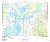
1954 Map of Ophir
USGS Topo · Published 1984About this map
The Innoko River dominates this interior Alaska landscape, winding through a complex network of wetlands that define the Innoko National Wildlife Refuge and the Innoko Wilderness. The map captures a region defined by its waterway-driven logistics, where small river settlements like Dishkakat, Rennies Landing, and Cripple Landing served as vital points of access. To the south, the settlement of Ophir stands at the center of a mining district, evidenced by the Esperanto Placer Mine and several unnamed placer operations along the surrounding creeks.
Find a feature on this map
83 named features on this map. Tap any name to fly to it.
Don’t see what you’re looking for? This feature index may not catch every label — zoom into the map to look around manually.
Map Details
Editions of this 1954 Ophir Map
3 editions found

Other maps of this area

1945 · Nulato
USGS Topo · 1:250,000

1948 · Norton Bay
USGS Topo · 1:250,000

1949 · McGrath
USGS Topo · 1:250,000

1950 · Medfra
USGS Topo · 1:250,000

1950 · McGrath
USGS Topo · 1:250,000

1951 · Ophir
USGS Topo · 1:250,000

1951 · Nulato
USGS Topo · 1:250,000

1951 · Unalakleet
USGS Topo · 1:250,000

1951 · Ruby
USGS Topo · 1:250,000

1951 · Norton Bay
USGS Topo · 1:250,000