1964 Map of Orange City
USGS Topo · Published 1981About this map
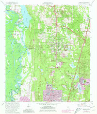
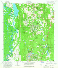
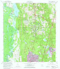
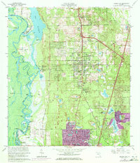
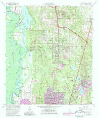
Hontoon Island State Park and the winding St Johns River anchor the western edge of this map, illustrating a landscape defined by its intricate river bends and swampy islands. The 1980 photorevision captures the expansion of Deltona and DeBary in the southeast, contrasting with the established grid of Orange City. These residential developments are seen encroaching on the lakes and pine lands, while the Seaboard Coast Line railroad maintains its north-south corridor through the center of the county. Local heritage is visible in landmarks such as Mt Terrain Ch, Hollywood Cemetery, and Blue Springs, a noted natural feature along the river. The map tracks the shift from a river-dependent economy to a growing interior suburban network, visible in the new street names of Orange City Hills and the transition of once-remote terrain into recreation areas like De Land Marina Park.
Find a feature on this map
67 named features on this map. Tap any name to fly to it.
Don’t see what you’re looking for? This feature index may not catch every label — zoom into the map to look around manually.
Map Details
Editions of this 1964 Orange City Map
5 editions found
Other maps of this area

1954 · Daytona Beach
USGS Topo · 1:250,000

1955 · Orlando
USGS Topo · 1:250,000

1957 · Orlando
USGS Topo · 1:250,000

1958 · Orlando
USGS Topo · 1:250,000

1958 · Daytona Beach
USGS Topo · 1:250,000

1962 · Orlando
USGS Topo · 1:250,000

1962 · Pine Lakes
USGS Topo · 1:24,000
1962 · Daytona Beach SW
USGS Topo · 1:24,000

1962 · Lake Woodruff
USGS Topo · 1:24,000

1964 · Daytona Beach
USGS Topo · 1:250,000