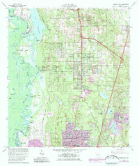
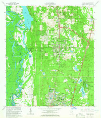
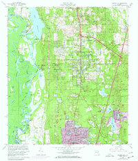
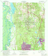
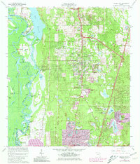
1964 Map of Orange City
USGS Topo · Published 1984About this map
The St Johns River and its intricate network of sloughs and lagoons dominate the western edge of this 1960s landscape, where Hontoon Island State Park sits preserved amidst a complex system of waterways including the Dead River and Snake Creek. To the east, the terrain rises into the settlement of Orange City, showing a transition from the river-dependent landings of the past toward the modern expansion of Deltona and DeBary. This era captures a period of growth evidenced by new residential developments and trailer parks appearing near established sites like St Barnabas Ch and the Seaboard Coast Line railroad. The map records several lakeside communities and landmarks, from Lake Beresford in the north down to Lake of the Woods in the south, illustrating how mid-century Florida suburbanization began to encircle the area's natural spring-fed basins and pine islands.
Find a feature on this map
69 named features on this map. Tap any name to fly to it.
Don’t see what you’re looking for? This feature index may not catch every label — zoom into the map to look around manually.
Map Details
Editions of this 1964 Orange City Map
5 editions found
Other maps of this area

1954 · Daytona Beach
USGS Topo · 1:250,000

1955 · Orlando
USGS Topo · 1:250,000

1957 · Orlando
USGS Topo · 1:250,000

1958 · Orlando
USGS Topo · 1:250,000

1958 · Daytona Beach
USGS Topo · 1:250,000

1962 · Orlando
USGS Topo · 1:250,000

1962 · Pine Lakes
USGS Topo · 1:24,000
1962 · Daytona Beach SW
USGS Topo · 1:24,000

1962 · Lake Woodruff
USGS Topo · 1:24,000

1964 · Daytona Beach
USGS Topo · 1:250,000