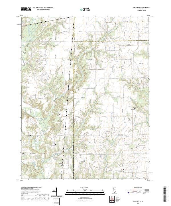
2024 Map of Orchardville
USGS Topo · Published 2024About this map
Orchardville and the surrounding rural landscape of Wayne County are defined by a complex network of creeks and small family cemeteries that trace the heritage of this Illinois region. The terrain is deeply carved by the Skillet Fork and its tributaries, including Nickolson Creek, Poplar Creek, and Turner Creek, which create a series of low-lying valleys and ridges. Smaller settlements like Union Town, Helm, and Christian Home are connected by a grid of county roads that navigate the local topography. For those researching local lineages, the map identifies numerous burial sites such as Burroughs Cem, Harmon Cem, and Mount Pleasant Cem. The convergence of Marion and Clay county lines at the map's northern edge highlights the historical administrative boundaries that have influenced local land division and settlement patterns for generations.
Find a feature on this map
81 named features on this map. Tap any name to fly to it.
Don’t see what you’re looking for? This feature index may not catch every label — zoom into the map to look around manually.
Map Details
Editions of this 2024 Orchardville Map
This is the sole edition of this map. No revisions or reprints were ever made.
Other maps of this area

1933 · Mount Vernon
USGS Topo · 1:48,000

1934 · Salem
USGS Topo · 1:62,500

1938 · Salem
USGS Topo · 1:62,500

1940 · Mount Vernon
USGS Topo · 1:62,500

1947 · Wayne City
USGS Topo · 1:62,500

1952 · Xenia
USGS Topo · 1:62,500

1958 · Belleville
USGS Topo · 1:250,000

1962 · Belleville
USGS Topo · 1:250,000

1965 · Iuka
USGS Topo · 1:24,000
1965 · Harmony
USGS Topo · 1:24,000