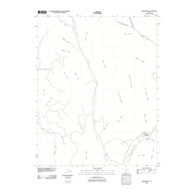
2010 Map of Orderville
USGS Topo · Published 2010About this map
The settlement of Orderville anchors the southeast corner of this landscape, situated along the East Fork Virgin River as it winds through Long Valley. This 2010 survey illustrates the high-desert geography where dramatic landforms like the Elkheart Cliffs and Muddy Point overlook a complex network of drainages including Mineral Gulch, Hellhole Canyon, and Lydias Canyon. The map reveals the local infrastructure of the modern era, centering on the Orderville Post Office and the residential layout along S Center St. Outside the town center, the terrain is defined by its verticality and water management, with narrow pathways like Muddy Creek Rd following the course of Muddy Creek. Genealogists will find the Orderville Cemetery clearly marked, while researchers interested in historical resource use can locate Coal Hollow and the namesake Winsor Cove to the south.
Find a feature on this map
39 named features on this map. Tap any name to fly to it.
Don’t see what you’re looking for? This feature index may not catch every label — zoom into the map to look around manually.
Map Details
Editions of this 2010 Orderville Map
This is the sole edition of this map. No revisions or reprints were ever made.
Other maps of this area

1886 · Kanab
USGS Topo · 1:250,000

1953 · Cedar City
USGS Topo · 1:250,000

1954 · Orderville Canyon SE
USGS Topo · 1:24,000

1956 · Springdale NE
USGS Topo · 1:24,000

1957 · Orderville Canyon NE
USGS Topo · 1:24,000

1957 · Kanab
USGS Topo · 1:62,500

1958 · Cedar City
USGS Topo · 1:250,000

1958 · Orderville
USGS Topo · 1:62,500

1962 · Cedar City
USGS Topo · 1:250,000
1980 · Clear Creek Mountain
USGS Topo · 1:24,000