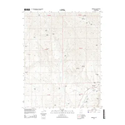
2014 Map of Orderville
USGS Topo · Published 2014About this map
Orderville stands as the primary settlement on this Southern Utah landscape, located where the E Fork Virgin River meets the southern reaches of Long Valley. The town's layout is clearly defined by local routes such as W State St and E State St, with the Orderville Cem situated on the western edge of the village. The surrounding geography is a complex network of drainage systems and high points, including the prominent Elkheart Cliffs to the southeast and the branching paths of Muddy Cr. The terrain is deeply incised by numerous canyons and hollows, such as Lydias Canyon and Hellhole Canyon, illustrating the vertical nature of the Virgin River's watershed. For researchers, these named landmarks like Winsor Cove and Mineral Gulch provide specific points of reference for tracing historic land use and early routes through the canyon country.
Find a feature on this map
49 named features on this map. Tap any name to fly to it.
Don’t see what you’re looking for? This feature index may not catch every label — zoom into the map to look around manually.
Map Details
Editions of this 2014 Orderville Map
This is the sole edition of this map. No revisions or reprints were ever made.
Other maps of this area

1886 · Kanab
USGS Topo · 1:250,000

1953 · Cedar City
USGS Topo · 1:250,000

1954 · Orderville Canyon SE
USGS Topo · 1:24,000

1956 · Springdale NE
USGS Topo · 1:24,000

1957 · Orderville Canyon NE
USGS Topo · 1:24,000

1957 · Kanab
USGS Topo · 1:62,500

1958 · Cedar City
USGS Topo · 1:250,000

1958 · Orderville
USGS Topo · 1:62,500

1962 · Cedar City
USGS Topo · 1:250,000
1980 · Clear Creek Mountain
USGS Topo · 1:24,000