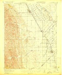
1919 Map of Orestimba
USGS Topo · Published 1919About this map
Patterson stands as a primary hub of development in this Central Valley corridor, situated within the historical bounds of the Rancho Del Puerto. The 1918 survey illustrates a landscape undergoing a significant transformation from traditional ranching to intensive irrigation-based agriculture. A complex network of water infrastructure, including the San Joaquin and King's River Canal and several labeled laterals like Lateral A and Lateral B, branches out toward the San Joaquin River. This system is anchored by the Stimba Pumping Station, signaling the era's reliance on engineered water management.
Find a feature on this map
37 named features on this map. Tap any name to fly to it.
Don’t see what you’re looking for? This feature index may not catch every label — zoom into the map to look around manually.
Map Details
Editions of this 1919 Orestimba Map
3 editions found

Other maps of this area

1913 · Romain
USGS Topo · 1:31,680

1915 · Westport
USGS Topo · 1:31,680

1915 · Westley
USGS Topo · 1:31,680

1916 · Mitchell School
USGS Topo · 1:31,680

1916 · Crows Landing
USGS Topo · 1:31,680

1916 · Patterson
USGS Topo · 1:31,680

1916 · Romain
USGS Topo · 1:31,680

1916 · Ceres
USGS Topo · 1:31,680

1917 · Newman
USGS Topo · 1:31,680

1918 · Gustine
USGS Topo · 1:31,680