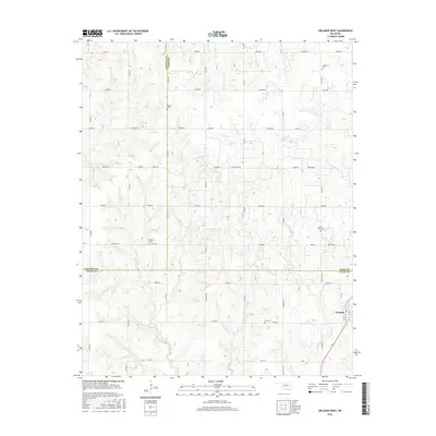
2016 Map of Orlando West
USGS Topo · Published 2016About this map
Orlando anchors the southeastern corner of this landscape, situated where the borders of Garfield, Noble, and Logan counties converge. This prairie region is defined by a dense network of sectional roads and small cemeteries that speak to the early settlement of the Oklahoma territory. Five distinct burial grounds are scattered across the quadrangle, including the Pioneer Cem to the north and the German Cem near the center, reflecting the diverse heritage of the families who established the local farming community. The terrain is carved by numerous watercourses, with the headwaters of W Beaver Cr, E Warren Cr, and Middle Beaver Cr creating a rolling drainage pattern. These creeks eventually feed into the larger river systems of central Oklahoma, while named roads like Coltrane Rd and Air Depot Rd provide modern connectivity to the historic townsite.
Find a feature on this map
52 named features on this map. Tap any name to fly to it.
Don’t see what you’re looking for? This feature index may not catch every label — zoom into the map to look around manually.
Map Details
Editions of this 2016 Orlando West Map
This is the sole edition of this map. No revisions or reprints were ever made.
Other maps of this area

1893 · Mulhall
USGS Topo · 1:62,500

1893 · Lovell
USGS Topo · 1:62,500

1955 · Enid
USGS Topo · 1:250,000

1956 · Garber
USGS Topo · 1:62,500

1958 · Enid
USGS Topo · 1:250,000

1972 · Perry
USGS Topo · 1:24,000

1972 · Lucien
USGS Topo · 1:24,000
1974 · Mulhall
USGS Topo · 1:24,000
1974 · Orlando East
USGS Topo · 1:24,000

1974 · Marshall East
USGS Topo · 1:24,000