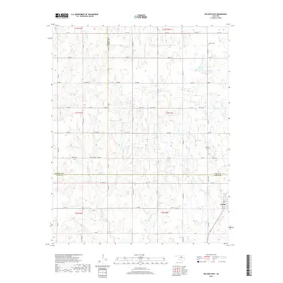
2018 Map of Orlando West
USGS Topo · Published 2018About this map
Orlando sits at the southeastern corner of this modern survey, where the boundaries of Noble and Logan counties meet. The landscape is defined by the headwaters of several drainages, including Cow Cr and Little Stillwater Cr, which carve through the plains of Central Oklahoma. This map serves as an important genealogical resource, as it documents several rural burial grounds that speak to the early settlement of the region. Distinctive sites like German Cem, Pioneer Cem, and Lawnview Cem are preserved among the section-line roads. The drainage patterns of W Beaver Cr and Middle Beaver Cr dominate the central and southern portions of the quadrangle, illustrating the natural watercourses that have dictated land use and road placement since the land run era.
Find a feature on this map
48 named features on this map. Tap any name to fly to it.
Don’t see what you’re looking for? This feature index may not catch every label — zoom into the map to look around manually.
Map Details
Editions of this 2018 Orlando West Map
This is the sole edition of this map. No revisions or reprints were ever made.
Other maps of this area

1893 · Mulhall
USGS Topo · 1:62,500

1893 · Lovell
USGS Topo · 1:62,500

1955 · Enid
USGS Topo · 1:250,000

1956 · Garber
USGS Topo · 1:62,500

1958 · Enid
USGS Topo · 1:250,000

1972 · Perry
USGS Topo · 1:24,000

1972 · Lucien
USGS Topo · 1:24,000
1974 · Mulhall
USGS Topo · 1:24,000
1974 · Orlando East
USGS Topo · 1:24,000

1974 · Marshall East
USGS Topo · 1:24,000