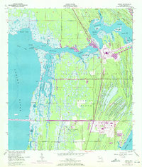
1949 Map of Orsino
USGS Topo · Published 1972About this map
The John F Kennedy Space Center (NASA) dominates the central landscape of Merritt Island, reflecting a period of intense technological expansion in the late 20th century. This 1970 revision highlights the massive infrastructure of the Space Age, including the Vehicle Assembly Building, the Launch Control Center, and the sprawling Industrial Area. These modern facilities are overlaid upon a complex network of coastal wetlands and waterways, such as Banana Creek and the Indian River. Older settlements like Orsino and small landmarks like Hubs Landing or Palma Crystal provide a contrast to the high-tech development, showing the transition from a traditional Florida coastal environment to a global center for aerospace activity. The map clearly delineates the massive Turning Basin and the primary transit corridors of NASA Parkway West and NASA Parkway East.
Find a feature on this map
46 named features on this map. Tap any name to fly to it.
Don’t see what you’re looking for? This feature index may not catch every label — zoom into the map to look around manually.
Map Details
Editions of this 1949 Orsino Map
3 editions found
Other maps of this area

1949 · Orsino
USGS Topo · 1:24,000

1949 · False Cape
USGS Topo · 1:24,000

1949 · Titusville
USGS Topo · 1:24,000

1949 · Courtenay
USGS Topo · 1:24,000

1949 · Wilson
USGS Topo · 1:24,000

1949 · Mims
USGS Topo · 1:24,000

1949 · Sharpes
USGS Topo · 1:24,000

1951 · False Cape
USGS Topo · 1:24,000

1951 · Courtenay
USGS Topo · 1:24,000

1951 · Sharpes
USGS Topo · 1:24,000