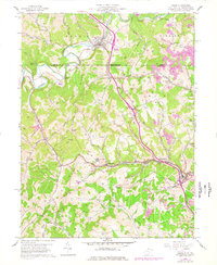
1958 Map of Osage
USGS Topo · Published 1977About this map
Mount Morris sits at the northern edge of this West Virginia and Pennsylvania borderland, where the Dunkard Creek drainage carves through the landscape. The mid-century economy of the region is clearly visible through the extensive network of the Monongahela railroad and numerous coal industry features, including a Conveyor and prominent Strip Mines. The geography is defined by high points like Dunkard Ridge and Sutton Knob, with settlements like Pursglove, Cassville, and Osage clustered along the southern valley floors.
Find a feature on this map
66 named features on this map. Tap any name to fly to it.
Don’t see what you’re looking for? This feature index may not catch every label — zoom into the map to look around manually.
Map Details
Editions of this 1958 Osage Map
3 editions found

Other maps of this area

1900 · Masontown
USGS Topo · 1:62,500

1901 · Waynesburg
USGS Topo · 1:62,500

1902 · Morgantown
USGS Topo · 1:62,500

1903 · Masontown
USGS Topo · 1:62,500

1904 · Blacksville
USGS Topo · 1:62,500

1904 · Waynesburg
USGS Topo · 1:62,500

1923 · Blacksville
USGS Topo · 1:62,500

1925 · Blacksville
USGS Topo · 1:62,500

1925 · Morgantown
USGS Topo · 1:62,500

1931 · Masontown
USGS Topo · 1:62,500