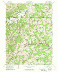
1958 Map of Osage
USGS Topo · Published 1970About this map
Dunkard Creek winds through the northern portion of this landscape, crossing the state line between Mount Morris, Pennsylvania, and the coal-rich hills of West Virginia. The terrain is deeply carved by numerous runs and hollows, where small settlements like Cassville, Pursglove, and Jere grew alongside the industrial infrastructure of the mid-20th century. The influence of the local extraction economy is evident in the presence of a Conveyor, strip mines, and several large mine dumps situated near the Monongahela Railway.
Find a feature on this map
65 named features on this map. Tap any name to fly to it.
Don’t see what you’re looking for? This feature index may not catch every label — zoom into the map to look around manually.
Map Details
Editions of this 1958 Osage Map
3 editions found

Other maps of this area

1900 · Masontown
USGS Topo · 1:62,500

1901 · Waynesburg
USGS Topo · 1:62,500

1902 · Morgantown
USGS Topo · 1:62,500

1903 · Masontown
USGS Topo · 1:62,500

1904 · Blacksville
USGS Topo · 1:62,500

1904 · Waynesburg
USGS Topo · 1:62,500

1923 · Blacksville
USGS Topo · 1:62,500

1925 · Blacksville
USGS Topo · 1:62,500

1925 · Morgantown
USGS Topo · 1:62,500

1931 · Masontown
USGS Topo · 1:62,500