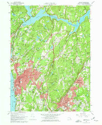
1967 Map of Ossining
USGS Topo · Published 1974About this map
Sing Sing Prison anchors the riverfront of Ossining on the eastern bank of the Hudson River, marking a dense corridor of institutional and educational history in the mid-1960s. The landscape is notably defined by major religious and academic campuses, including the sprawling Maryknoll Seminary, Kings College, and Briarcliff College. To the north, the massive New Croton Reservoir dominates the terrain, held by the New Croton Dam and surrounded by the rising elevations of Turkey Mtn and Bald Mtn. This era shows Westchester County as a hub of suburban development interspersed with extensive country clubs like Sleepy Hollow Country Club and specialized industry, such as the Emery Mines near the northern boundary. The Penn Central railroad tracks trace the shoreline, connecting riverside settlements like Scarborough and Croton-on-Hudson to the broader regional network.
Find a feature on this map
171 named features on this map. Tap any name to fly to it.
Don’t see what you’re looking for? This feature index may not catch every label — zoom into the map to look around manually.
Map Details
Editions of this 1967 Ossining Map
4 editions found
Other maps of this area

1892 · Stamford
USGS Topo · 1:62,500

1892 · West Point
USGS Topo · 1:62,500

1892 · Carmel
USGS Topo · 1:62,500

1892 · Tarrytown
USGS Topo · 1:62,500

1893 · Carmel
USGS Topo · 1:62,500

1893 · Stamford
USGS Topo · 1:62,500

1893 · Tarrytown
USGS Topo · 1:62,500

1894 · West Point
USGS Topo · 1:62,500

1894 · Carmel
USGS Topo · 1:62,500

1899 · Stamford
USGS Topo · 1:62,500