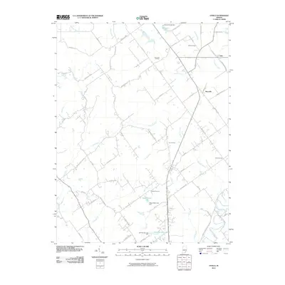
2010 Map of Otisco
USGS Topo · Published 2010About this map
Marysville and Nabb serve as the primary hubs in this corner of Clark County, situated amidst a landscape defined by an intricate network of drainage ways and small reservoirs. The area's social history is anchored by several burial grounds, including Bethel Cemetery, Walnut Hill Cemetery, and the centrally located Kern Cemetery, which often mark the sites of early community focal points. Water management is a visible priority across the terrain, evidenced by the Marysville Lake Dam, Shady Hollow Lake Dam, and Jack Pine Park Lake Dam. These man-made bodies of water supplement natural features like Fourteenmile Creek and Sinking Fork, illustrating how local residents have shaped the hydrology of the region over time. The road network, including the curiously named E Werewolf Ln and Opossum Trot Rd, follows the undulations of the local topography between these wooded creek valleys.
Find a feature on this map
71 named features on this map. Tap any name to fly to it.
Don’t see what you’re looking for? This feature index may not catch every label — zoom into the map to look around manually.
Map Details
Editions of this 2010 Otisco Map
This is the sole edition of this map. No revisions or reprints were ever made.
Other maps of this area

1905 · Prospect
USGS Topo · 1:62,500

1912 · Prospect
USGS Topo · 1:62,500

1937 · Charlestown
USGS Topo · 1:24,000

1938 · Owen
USGS Topo · 1:24,000

1938 · Speed
USGS Topo · 1:24,000

1947 · Speed
USGS Topo · 1:24,000

1947 · Scottsburg
USGS Topo · 1:24,000

1948 · Owen
USGS Topo · 1:24,000

1949 · Henryville
USGS Topo · 1:24,000
1950 · Charlestown
USGS Topo · 1:24,000