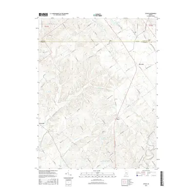
2016 Map of Otisco
USGS Topo · Published 2016About this map
Otisco and Marysville occupy the central corridor of this Clark County landscape, where the agricultural uplands transition into the drainage basins of Silver Creek and Fourteenmile Creek. This modern survey documents the contemporary road network and rural layout, featuring a high concentration of burial sites that provide a clear view into the region's local genealogy. From Seedtick Cem in the south to Walnut Hill Cem near the northern boundary, these sites anchor the long-standing communities of southern Indiana. The terrain is defined by a series of distinct drainages, including Clegg Creek, Sinking Fork, and Henthorn Br, which have shaped the movement of local traffic and the placement of small reservoirs like Shady Hollow Lake. The western edge of the map touches the outskirts of Henryville, showing the area just before it meets the larger state forest lands to the west.
Find a feature on this map
89 named features on this map. Tap any name to fly to it.
Don’t see what you’re looking for? This feature index may not catch every label — zoom into the map to look around manually.
Map Details
Editions of this 2016 Otisco Map
This is the sole edition of this map. No revisions or reprints were ever made.
Other maps of this area

1905 · Prospect
USGS Topo · 1:62,500

1912 · Prospect
USGS Topo · 1:62,500

1937 · Charlestown
USGS Topo · 1:24,000

1938 · Owen
USGS Topo · 1:24,000

1938 · Speed
USGS Topo · 1:24,000

1947 · Speed
USGS Topo · 1:24,000

1947 · Scottsburg
USGS Topo · 1:24,000

1948 · Owen
USGS Topo · 1:24,000

1949 · Henryville
USGS Topo · 1:24,000
1950 · Charlestown
USGS Topo · 1:24,000