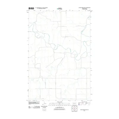
2011 Map of Otter Creek East
USGS Topo · Published 2011About this map
The Heart River winds through this rural landscape in Morton County, creating a series of deep loops as it flows eastward. This drainage system is the primary geographic feature of the region, joined by smaller tributaries including Otter Creek and Beaver Creek. The map shows a classic section-line road grid characteristic of the northern plains, where gravel routes like 40th Ave and 58th St delineate large agricultural tracts. This 2011 survey reveals the enduring rural character of the area, where human presence is defined by the intersection of these long section roads with the irregular, natural paths of the river valleys. Local transportation is facilitated by County Rd 84, which provides the primary east-west corridor across the northern portion of the terrain.
Find a feature on this map
20 named features on this map. Tap any name to fly to it.
Don’t see what you’re looking for? This feature index may not catch every label — zoom into the map to look around manually.
Map Details
Editions of this 2011 Otter Creek East Map
This is the sole edition of this map. No revisions or reprints were ever made.
Other maps of this area

1954 · Bismarck
USGS Topo · 1:250,000

1958 · Bismarck
USGS Topo · 1:250,000

1980 · Otter Creek West
USGS Topo · 1:24,000

1980 · Green Ridge
USGS Topo · 1:24,000

1980 · Otter Creek East
USGS Topo · 1:24,000

1980 · Almont East
USGS Topo · 1:24,000

1980 · Lark
USGS Topo · 1:24,000

1980 · Dogtooth Buttes
USGS Topo · 1:24,000
1980 · Fish Creek Lake
USGS Topo · 1:24,000

1980 · Nygren Dam
USGS Topo · 1:24,000