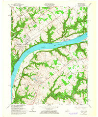
1961 Map of Owen
USGS Topo · Published 1964About this map
The Ohio River serves as the central artery and dividing line between Indiana and Kentucky in this early 1960s topographic study. On the Indiana side, the massive U S Military Reservation Indiana Arsenal occupies a significant portion of the landscape, including the Devils Backbone and the site of the Historic Fort. The map details the mid-century transition of the Kentucky shoreline into residential and recreational developments, featuring Harmony Lake Estates, Oldham Acres, and Belknap Beach. Rural life remains anchored by established landmarks such as Salem Ch, Shiloh Ch, and the Liberty Sch. Significant water features like Fourteenmile Creek and Harrods Creek cut through the terrain, while Rose Island and Eighteenmile Island sit within the river’s flow, highlighting the area’s longstanding relationship with river navigation and leisure.
Find a feature on this map
55 named features on this map. Tap any name to fly to it.
Don’t see what you’re looking for? This feature index may not catch every label — zoom into the map to look around manually.
Map Details
Editions of this 1961 Owen Map
4 editions found
Other maps of this area

1905 · Prospect
USGS Topo · 1:62,500

1912 · Prospect
USGS Topo · 1:62,500

1932 · La Grange
USGS Topo · 1:62,500

1937 · Jeffersonville
USGS Topo · 1:24,000

1937 · Charlestown
USGS Topo · 1:24,000

1938 · Owen
USGS Topo · 1:24,000

1939 · Bethlehem
USGS Topo · 1:24,000

1946 · Jeffersonville
USGS Topo · 1:24,000

1948 · Bethlehem
USGS Topo · 1:24,000

1948 · Owen
USGS Topo · 1:24,000