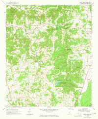
1964 Map of Owens Wells
USGS Topo · Published 1965About this map
The settlement of Owens Wells anchors this mid-century portrait of Holmes County, Mississippi, where the Illinois Central railroad cuts through a landscape defined by creeks and small communities. A significant historical boundary, the Old Indian Treaty Bdy, traverses the northeastern corner, marking an era of shifting territorial lines. The area is dense with community landmarks such as Union Paradise Ch and Gages Springs Cem, reflecting a rural social structure built around local congregations and family burying grounds. In the southeast, Holmes County State Park provides a concentrated area of recreation near Macedonia Cem. The railroad network connects McMillan and West Hill before reaching Aberdeen Junction near the banks of the Big Black River, showing the importance of rail transport to these interior Mississippi settlements in the early 1960s.
Find a feature on this map
33 named features on this map. Tap any name to fly to it.
Don’t see what you’re looking for? This feature index may not catch every label — zoom into the map to look around manually.
Map Details
Editions of this 1964 Owens Wells Map
3 editions found
Other maps of this area

1940 · Lexington
USGS Topo · 1:62,500

1953 · Meridian
USGS Topo · 1:250,000

1953 · Greenwood
USGS Topo · 1:250,000

1953 · West Point
USGS Topo · 1:250,000

1955 · Jackson
USGS Topo · 1:250,000

1956 · Greenwood
USGS Topo · 1:250,000

1957 · Meridian
USGS Topo · 1:250,000

1957 · Lexington
USGS Topo · 1:62,500

1958 · West Point
USGS Topo · 1:250,000

1958 · Lexington
USGS Topo · 1:62,500