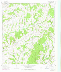
1962 Map of Owensville
USGS Topo · Published 1978About this map
The community of Nesbitt and the settlement at Owensville anchor this map of central Texas, depicting a landscape of rural prairies and creek-cut woodlots. The terrain transitions from the open stretches of Beck Prairie to the dense network of drainage systems feeding into Walnut Creek and South Walnut Creek. The cultural footprint is defined by small country congregations and burial grounds, such as Beck Prairie Ch and its associated Beck Prairie Cem, alongside the Little Mississippi Cem located near the headwaters of Little Mud Creek. In the southeast corner, the Missouri Pacific railroad corridor cuts across the land, reflecting the transport infrastructure that supported local agriculture. Industrial activity is represented by scattered resource sites like the Claypit and Gravel Pit, which sit among the drainage basins of Mud Creek and Spring Branch.
Find a feature on this map
23 named features on this map. Tap any name to fly to it.
Don’t see what you’re looking for? This feature index may not catch every label — zoom into the map to look around manually.
Map Details
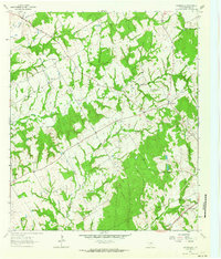
Editions of this 1962 Owensville Map
2 editions found
Other maps of this area

1927 · Marquez
USGS Topo · 1:62,500

1930 · Marquez
USGS Topo · 1:62,500

1954 · Waco
USGS Topo · 1:250,000

1954 · Austin
USGS Topo · 1:250,000

1955 · Waco
USGS Topo · 1:250,000

1961 · Hearne North
USGS Topo · 1:24,000

1962 · Calvert
USGS Topo · 1:24,000

1962 · Wheelock
USGS Topo · 1:24,000

1962 · Hammond
USGS Topo · 1:24,000

1962 · Bremond
USGS Topo · 1:24,000