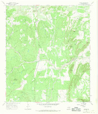
1967 Map of Oxford
USGS Topo · Published 1969About this map
The small community of Oxford sits at the northern edge of this Llano County landscape, where the northern foothills of the Riley Mountains meet the surrounding plains. By the late 1960s, the area remained largely rural, defined by a network of creeks like Sandy Creek and Crabapple Creek that cut through the undulating terrain. The presence of Gravel Pits and the Fowler Ranch suggests a local economy tied to the earth and livestock. Further south, the map details prominent relief such as Cedar Mountain and Bowie Mountain, along with smaller landmarks like Potato Hill and Fool Gap. This survey documents a quiet Texas interior before modern expansion, preserving the locations of springs and small drainage features such as Lost Hollow and Goldmine Creek that provided the essential water sources for early ranching and settlement.
Find a feature on this map
37 named features on this map. Tap any name to fly to it.
Don’t see what you’re looking for? This feature index may not catch every label — zoom into the map to look around manually.
Map Details
Editions of this 1967 Oxford Map
2 editions found
Other maps of this area

1887 · Llano
USGS Topo · 1:125,000

1894 · Fredericksburg
USGS Topo · 1:125,000

1894 · Llano
USGS Topo · 1:125,000

1904 · Llano
USGS Topo · 1:125,000

1909 · Llano
USGS Topo · 1:125,000

1918 · Llano
USGS Topo · 1:125,000

1954 · Llano
USGS Topo · 1:250,000

1955 · Llano
USGS Topo · 1:250,000

1956 · Llano
USGS Topo · 1:250,000
1960 · Scotts Crossing
USGS Topo · 1:24,000