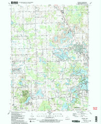
1991 Map of Oxford
USGS Topo · Published 1991About this map
The northern reaches of Oakland County in the late 1980s reveal a landscape of glacial lakes and growing residential pockets interspersed with active industry. The Grand Trunk Western railroad corridor anchors the eastern side of the sheet, passing through the village of Oxford, while the surrounding terrain is heavily defined by the extraction economy of several large Gravel Pit operations. These industrial sites sit in close proximity to prominent local landmarks like the St Josephs Convent and DeLima College.
Find a feature on this map
88 named features on this map. Tap any name to fly to it.
Don’t see what you’re looking for? This feature index may not catch every label — zoom into the map to look around manually.
Map Details
Editions of this 1991 Oxford Map
2 editions found
Other maps of this area

1907 · Pontiac
USGS Topo · 1:62,500

1908 · Rochester
USGS Topo · 1:62,500

1936 · Clarkston
USGS Topo · 1:31,680

1936 · Rochester
USGS Topo · 1:31,680

1936 · Pontiac North
USGS Topo · 1:31,680

1943 · Clarkston
USGS Topo · 1:24,000

1943 · Pontiac North
USGS Topo · 1:24,000

1943 · Ortonville
USGS Topo · 1:24,000

1943 · Lake Orion
USGS Topo · 1:24,000

1943 · Oxford
USGS Topo · 1:24,000
Featured Places
- Orion Charter Township, MI
- Independence Charter Township, MI
- Oxford Charter Township, MI
- Oxford, MI
- Lake Orion, MI