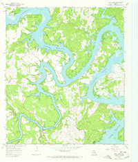
1967 Map of Pace Bend
USGS Topo · Published 1970About this map
The winding curves of the Colorado River and the newly formed fingers of Lake Travis define this Central Texas landscape at a time of significant transition. The map captures the rugged shoreline where the river meets the lake at a normal pool elevation of 681 feet, creating dramatic peninsulas like Pace Bend and Muleshoe Bend. Historically significant sites, including the Post Oak Bend Cem and Haynie Flat Cem, are preserved on higher ground above the inundation zones. The presence of Old Ferry Road and multiple private runways like the Paleface Landing Strip suggests a shift from traditional river crossings to modern ranching and recreational accessibility. The convergence of the Pedernales River and Lake Travis near the southern edge highlights the complex hydrology of the Edwards Plateau during the late 1960s.
Find a feature on this map
33 named features on this map. Tap any name to fly to it.
Don’t see what you’re looking for? This feature index may not catch every label — zoom into the map to look around manually.
Map Details
Editions of this 1967 Pace Bend Map
2 editions found
Other maps of this area

1887 · Blanco
USGS Topo · 1:125,000

1887 · Burnet
USGS Topo · 1:125,000

1893 · Georgetown
USGS Topo · 1:125,000

1893 · Burnet
USGS Topo · 1:125,000

1894 · Blanco
USGS Topo · 1:125,000

1896 · Austin
USGS Topo · 1:125,000

1897 · Austin
USGS Topo · 1:125,000

1903 · Burnet
USGS Topo · 1:125,000

1909 · Burnet
USGS Topo · 1:125,000

1910 · Austin
USGS Topo · 1:125,000