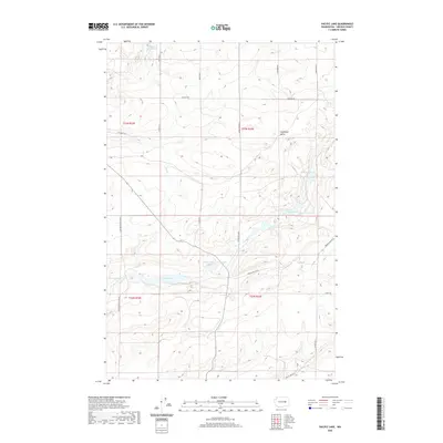
2020 Map of Pacific Lake
USGS Topo · Published 2020About this map
Pacific Lake and its surrounding basalt-scoured landscape define this portion of the Channeled Scablands in Lincoln County. The drainage patterns of Lake Cr and Duck Cr weave through a terrain marked by distinctive geological formations, most notably Coffeepot Butte in the northeastern quadrant. This area is characterized by numerous small water bodies including Eagle Spring Lake, Browns Lake, Tavares Lake, and Wederspahn Lake, many of which sit in depressions left by ancient glacial floods.
Find a feature on this map
25 named features on this map. Tap any name to fly to it.
Don’t see what you’re looking for? This feature index may not catch every label — zoom into the map to look around manually.
Map Details
Editions of this 2020 Pacific Lake Map
This is the sole edition of this map. No revisions or reprints were ever made.
Other maps of this area

1953 · Ritzville
USGS Topo · 1:250,000

1959 · Ritzville
USGS Topo · 1:250,000

1965 · Ritzville
USGS Topo · 1:250,000

1968 · Irby
USGS Topo · 1:24,000

1968 · Sylvan Lake
USGS Topo · 1:24,000

1968 · Coffeepot Lake
USGS Topo · 1:24,000

1968 · Pacific Lake
USGS Topo · 1:24,000
1968 · Odessa
USGS Topo · 1:24,000

1968 · Sullivan Lake
USGS Topo · 1:24,000

1969 · Almira SE
USGS Topo · 1:24,000