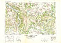
1961 Map of Paducah
USGS Topo · Published 1961About this map
The confluence of the Ohio River and the Mississippi River at Cairo anchors this mid-century mapping of the tri-state region. This document captures the complex hydrology of Southern Illinois, Western Kentucky, and Southeast Missouri during a period of significant hydroelectric and conservation activity. The massive Kentucky Reservoir is visible on the Tennessee River, while the newly managed lands of the Crab Orchard National Wildlife Refuge and Trail of Tears State Forest represent the era's focus on land reclamation and state-managed recreation.
Find a feature on this map
172 named features on this map. Tap any name to fly to it.
Don’t see what you’re looking for? This feature index may not catch every label — zoom into the map to look around manually.
Map Details
Editions of this 1961 Paducah Map
2 editions found
Other maps of this area

1903 · New Harmony
USGS Topo · 1:62,500

1903 · Patoka
USGS Topo · 1:125,000

1905 · Eldorado
USGS Topo · 1:62,500

1905 · New Haven
USGS Topo · 1:62,500

1906 · New Haven
USGS Topo · 1:62,500

1906 · Eldorado
USGS Topo · 1:62,500

1907 · Morganfield
USGS Topo · 1:62,500

1907 · Weingarten
USGS Topo · 1:62,500

1908 · Galatia
USGS Topo · 1:62,500

1908 · Princeton
USGS Topo · 1:62,500