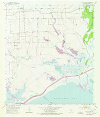
1952 Map of Palacios NE
USGS Topo · Published 1977About this map
Matagorda Bay defines the southern edge of this coastal landscape, where the land meets the sea through a complex network of marshes, bayous, and islands. In the early 1950s, the Intracoastal Waterway carved a distinct path across the wetlands, separating the mainland from features like Mad Island and Shell Island Lakes. The northern reaches of the map show a transition toward agricultural and industrial utility, marked by an extensive system of levees protecting land around Little Robbins Slough and Robbins Slough. Evidence of earlier settlement is found at the Citrus Grove Sch (Abandoned) in the northwest, while the growing energy sector is visible through numerous Gas Well and Gas Wells labels. The Colorado River flows along the eastern boundary, weaving past Wild Cow Island and McNabb Island, illustrating the dynamic nature of this delta region.
Find a feature on this map
30 named features on this map. Tap any name to fly to it.
Don’t see what you’re looking for? This feature index may not catch every label — zoom into the map to look around manually.
Map Details
Editions of this 1952 Palacios NE Map
2 editions found
Other maps of this area

1951 · Bay City
USGS Topo · 1:250,000

1952 · Palacios SE
USGS Topo · 1:24,000

1952 · Palacios Point
USGS Topo · 1:24,000

1952 · Matagorda
USGS Topo · 1:24,000

1952 · Blessing SE
USGS Topo · 1:24,000

1952 · Palacios
USGS Topo · 1:24,000
1952 · Matagorda SW
USGS Topo · 1:24,000

1952 · Blessing
USGS Topo · 1:24,000

1952 · Palacios NE
USGS Topo · 1:24,000

1952 · Wadsworth
USGS Topo · 1:24,000