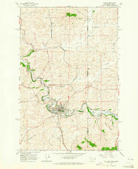
1964 Map of Palouse
USGS Topo · Published 1965About this map
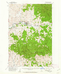
The Palouse River curves through this mid-1960s borderland where Whitman County, Washington, meets Latah County, Idaho. The town of Palouse serves as the focal point, situated at the confluence of the river and several major rail lines, including the Great Northern and the Washington Idaho and Montana River railroads. This era shows a landscape deeply tied to transport and grain handling, evidenced by the presence of Lairds and its storage bins just west of the town center. Local history is etched into the terrain with named points like Ladow Butte and Viola Ridge, while smaller outposts like Grinnell and Ladow suggest the distribution of early settlements. For genealogists, the Greenwood Cem is a prominent landmark, and the inclusion of private flight infrastructure like the Hanson Airstrip highlights the rural modernization of the region.
Find a feature on this map
25 named features on this map. Tap any name to fly to it.
Don’t see what you’re looking for? This feature index may not catch every label — zoom into the map to look around manually.
Map Details
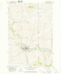
Editions of this 1964 Palouse Map
2 editions found
Other maps of this area

1903 · Oakesdale
USGS Topo · 1:125,000

1905 · Oakesdale
USGS Topo · 1:125,000

1910 · Pullman
USGS Topo · 1:125,000

1955 · Pullman
USGS Topo · 1:250,000

1955 · Spokane
USGS Topo · 1:250,000
1957 · Tensed
USGS Topo · 1:62,500

1958 · Spokane
USGS Topo · 1:250,000

1958 · Pullman
USGS Topo · 1:250,000
1960 · Robinson Lake
USGS Topo · 1:24,000
1960 · Potlatch
USGS Topo · 1:62,500