1964 Map of Palouse
USGS Topo · Published 1979About this map
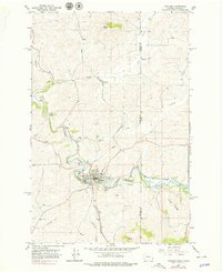
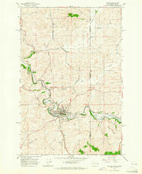
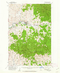
The town of Palouse serves as the focal point of this mid-1960s survey, situated along the winding banks of the Palouse River. This area is a significant intersection of rail history and geography, where the Great Northern, Pacific, and Washington Idaho and Montana railroads converge. The map documents the border between Whitman and Latah counties, capturing the transition from the rolling agricultural lands of eastern Washington into Idaho. Away from the central settlement, the landscape is dotted with smaller communities and rural landmarks like Ladow, Grinnell, and Lairds. Significant elevations such as Ladow Butte and Viola Ridge overlook the valley, while local infrastructure including Greenwood Cemetery, a Landing Strip, and numerous Gravel Pits reflect the economic and social fabric of the Palouse region during this era.
Find a feature on this map
24 named features on this map. Tap any name to fly to it.
Don’t see what you’re looking for? This feature index may not catch every label — zoom into the map to look around manually.
Map Details
Editions of this 1964 Palouse Map
2 editions found
Other maps of this area

1903 · Oakesdale
USGS Topo · 1:125,000

1905 · Oakesdale
USGS Topo · 1:125,000

1910 · Pullman
USGS Topo · 1:125,000

1955 · Pullman
USGS Topo · 1:250,000

1955 · Spokane
USGS Topo · 1:250,000
1957 · Tensed
USGS Topo · 1:62,500

1958 · Spokane
USGS Topo · 1:250,000

1958 · Pullman
USGS Topo · 1:250,000
1960 · Robinson Lake
USGS Topo · 1:24,000
1960 · Potlatch
USGS Topo · 1:62,500