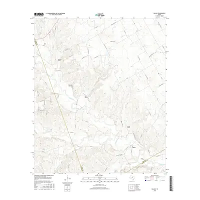
2016 Map of Paluxy
USGS Topo · Published 2016About this map
The Paluxy River carves through the landscape of Hood County, creating a series of distinctive drainage patterns marked by local names like Windmill Hollow and Buzzard Roost Hollow. This 2016 survey highlights the rural character of the region where Hood, Erath, and Somervell counties meet. Significant local landmarks for genealogists include the Glenn Cem in the northwest and Brooks Cem near the southern boundary, along with the eponymous settlement of Paluxy. The map documents a network of named country roads and topographic features, including Richardson Cr and Sycamore Cr, which feed into the primary river system. Near the northern edge, Texas A and M Lake provides a notable water feature amidst the complex terrain of ridges and draws that define this portion of the Texas landscape.
Find a feature on this map
62 named features on this map. Tap any name to fly to it.
Don’t see what you’re looking for? This feature index may not catch every label — zoom into the map to look around manually.
Map Details
Editions of this 2016 Paluxy Map
This is the sole edition of this map. No revisions or reprints were ever made.
Other maps of this area

1889 · Granbury
USGS Topo · 1:125,000

1890 · Stephenville
USGS Topo · 1:125,000

1920 · Stephenville
USGS Topo · 1:125,000

1923 · Granbury 2-a
USGS Topo · 1:48,000

1931 · Tolar
USGS Topo · 1:62,500

1954 · Dallas
USGS Topo · 1:250,000

1954 · Abilene
USGS Topo · 1:250,000

1958 · Dallas
USGS Topo · 1:250,000

1958 · Abilene
USGS Topo · 1:250,000
1960 · Tolar
USGS Topo · 1:24,000