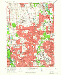
1963 Map of Park Ridge
USGS Topo · Published 1964About this map
Cook County's suburban expansion is vividly detailed in this mid-century survey, showcasing the dense network of residential blocks and institutions defining the North Shore and northwest Chicago suburbs. The landscape is characterized by its organized civic planning, featuring numerous religious and educational hubs like the Convent of the Holy Spirit, St Mary of the Lake Seminary, and Notre Dame High School. Transportation corridors such as the Tri-State Tollway and Edens Expressway frame the growth of Glenview, Park Ridge, and Skokie, while the Chicago and North Western railroad lines continue to anchor the historic village centers.
Find a feature on this map
172 named features on this map. Tap any name to fly to it.
Don’t see what you’re looking for? This feature index may not catch every label — zoom into the map to look around manually.
Map Details
Editions of this 1963 Park Ridge Map
Other maps of this area

1889 · Chicago
USGS Topo · 1:62,500

1891 · Chicago
USGS Topo · 1:62,500

1891 · Riverside
USGS Topo · 1:62,500

1893 · Riverside
USGS Topo · 1:62,500

1899 · Evanston
USGS Topo · 1:62,500

1900 · Chicago
USGS Topo · 1:62,500

1900 · Riverside
USGS Topo · 1:62,500

1900 · Highwood
USGS Topo · 1:62,500

1901 · Riverside
USGS Topo · 1:62,500

1901 · Chicago
USGS Topo · 1:62,500