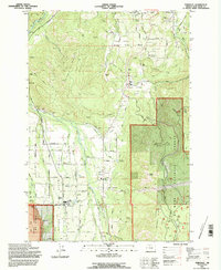
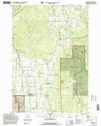
1994 Map of Parkdale
USGS Topo · Published 1996About this map
The agricultural and forested landscape of the Upper Hood River Valley is defined by a complex network of irrigation and water management, featuring the Farmers Ditch, Highline Canal, and the Emil Creek Res. Small clusters of settlement like Parkdale and the community of Mt Hood anchor the valley floor, surrounded by productive lands such as Willow Flat and Middle Valley. This 1990s field check documents the area's infrastructure, from the Hanel Airstrip to the Hood River Ranger Station, showing how the local economy relies on the Middle Fork and East Fork Hood River.
Find a feature on this map
85 named features on this map. Tap any name to fly to it.
Don’t see what you’re looking for? This feature index may not catch every label — zoom into the map to look around manually.
Map Details
Editions of this 1994 Parkdale Map
2 editions found
Other maps of this area

1924 · Mount Hood
USGS Topo · 1:125,000

1926 · Hood River
USGS Topo · 1:125,000

1927 · Mount Hood
USGS Topo · 1:125,000

1929 · Hood River
USGS Topo · 1:125,000

1930 · Dufur
USGS Topo · 1:125,000

1934 · Dufur
USGS Topo · 1:125,000

1934 · The Dalles
USGS Topo · 1:125,000

1953 · The Dalles
USGS Topo · 1:250,000

1956 · The Dalles
USGS Topo · 1:250,000

1957 · The Dalles
USGS Topo · 1:250,000