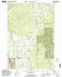
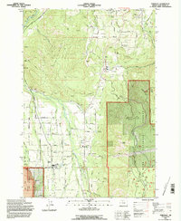
1994 Map of Parkdale
USGS Topo · Published 1996About this map
Agricultural valleys and the dense timber of Mount Hood National Forest meet in this mid-1990s survey. The landscape is defined by the Hood River and its various tributaries, including the East Fork Hood River and Middle Fork Hood River, which provide the irrigation necessary for the region's productive orchard lands. Scattered settlements like Parkdale, Mt Hood, and Odell are connected by a network of rural roads such as Massey Grade Road and Odell Hwy. Cultural landmarks important to local history and genealogy are documented, including the Upper Valley Cem and Shelley Cem. The terrain rises sharply from the valley floors toward distinctive peaks like Bald Butte and Middle Mountain, while the southern reaches of the map highlight unique geological features like the Lava Beds near Rogers Spring.
Find a feature on this map
67 named features on this map. Tap any name to fly to it.
Don’t see what you’re looking for? This feature index may not catch every label — zoom into the map to look around manually.
Map Details
Editions of this 1994 Parkdale Map
2 editions found
Other maps of this area

1924 · Mount Hood
USGS Topo · 1:125,000

1926 · Hood River
USGS Topo · 1:125,000

1927 · Mount Hood
USGS Topo · 1:125,000

1929 · Hood River
USGS Topo · 1:125,000

1930 · Dufur
USGS Topo · 1:125,000

1934 · Dufur
USGS Topo · 1:125,000

1934 · The Dalles
USGS Topo · 1:125,000

1953 · The Dalles
USGS Topo · 1:250,000

1956 · The Dalles
USGS Topo · 1:250,000

1957 · The Dalles
USGS Topo · 1:250,000