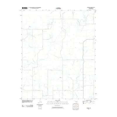
2010 Map of Parker
USGS Topo · Published 2010About this map
Muddy Boggy Creek and Caney Boggy Creek converge in this rural expanse of Oklahoma, where a network of section roads provides access to isolated homesteads and burial grounds. The landscape is defined by its complex drainage system, with Sweetwater Creek and Salt Creek cutting across the territory. Local history is anchored at the Pirie Cemetery and McCarty Cemetery, which serve as significant landmarks for genealogists and family researchers. The road network, including uniquely named routes like Burl Gwinn's Rd and Bill Ward Rd, reflects the area's agricultural division. This 2010 survey offers a detailed look at the rural property lines and watercourses that have shaped life in this part of Coal County for generations.
Find a feature on this map
31 named features on this map. Tap any name to fly to it.
Don’t see what you’re looking for? This feature index may not catch every label — zoom into the map to look around manually.
Map Details
Editions of this 2010 Parker Map
This is the sole edition of this map. No revisions or reprints were ever made.
Other maps of this area

1896 · Coalgate
USGS Topo · 1:125,000

1899 · Coalgate
USGS Topo · 1:125,000

1900 · Coalgate
USGS Topo · 1:125,000

1957 · Coalgate
USGS Topo · 1:24,000

1957 · Coalgate SE
USGS Topo · 1:24,000

1957 · Centrahoma
USGS Topo · 1:24,000

1957 · Tupelo NE
USGS Topo · 1:24,000

1957 · Ardmore
USGS Topo · 1:250,000

1963 · Ardmore
USGS Topo · 1:250,000
1967 · Wardville
USGS Topo · 1:24,000